


WE ARE UPGRADING
GeoWing Academy will be upgrading the Keystone Courses systematically over the coming weeks! The evolution of the powerful software platforms used in all GeoWing Academy training is incredible and we strive to keep you up to date with all things drone, photogrammetry and GIS. We are also making changes to the classroom for a better learning experience. If you have already joined or purchased a course, you will get instant access to all the upgraded content as soon as it is released.
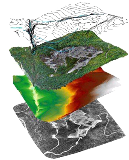
Using fantastic, state of the art, open source software platforms and off-the-shelf consumer drone technology, GeoWing Academy will train you how to digitise the world around you and convert that digital data into useful, understandable information that can be used in the industrial, environmental, agricultural fields and more allowing for enhanced decision making.
GeoWing Academy is aimed at complete beginners, as well as seasoned Graphics Information Software (GIS) users, conservationists, construction contractors, engineers, farmers, geospatial enthusiasts and drone pilots and will teach you how to apply these tools to collect and analyse real time data and provide rapid geospatial information faster and more accurately than ever before.”
“Very well structured, easy to follow and very insightful. I highly recommend GeoWing Academy” – Andy Woodford
“The fact that the drone data is provided with each course and that I did not need a drone to get started is fantastic” – Lucy Tarent
“I have discovered a whole new side to the use of drones that I never knew about! GeoWing Academy is leading the way in drone GIS training” – Ryan Oldfield
“I really enjoyed the courses, the projects are fun and provide real world examples in the use of drones and GIS” – Siobhan Cardosa
Take the FREE GeoWing Academy Mini Course here


Keystone
Courses
Conservation
Courses
Agricultural
Courses
Industrial
Courses

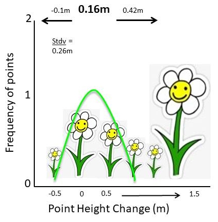
Open source software is changing the way we do things for the better as we can now have access to very complex code scripts written by very smart people and leverage these libraries for incredibly powerful data analysis.
Couple this with inexpensive off the shelf robotic technology that we can use as aerial “scanners” and the way we study the world changes forever.


WE ARE UPGRADING
GeoWing Academy will be upgrading the Keystone Courses systematically over the coming weeks! The evolution of the powerful software platforms used in all GeoWing Academy training is incredible and we strive to keep you up to date with all things drone, photogrammetry and GIS. We are also making changes to the classroom for a better learning experience. If you have already joined or purchased a course, you will get instant access to all the upgraded content as soon as it is released.
Using fantastic, state of the art, open source software platforms and off-the-shelf consumer drone technology, GeoWing Academy will train you how to digitise the world around you and convert that digital data into useful, understandable information that can be used in the industrial, environmental, agricultural fields and more allowing for enhanced decision making.
GeoWing Academy is aimed at complete beginners, as well as seasoned Geographic Information Software (GIS) users, conservationists, construction contractors, engineers, farmers, geospatial enthusiasts and drone pilots and will teach you how to apply these tools to collect and analyse real time data and provide rapid geospatial information faster and more accurately than ever before.”
Keystone
Courses
Conservation
Courses
Agricultural
Courses
Industrial
Courses
“Very well structured, easy to follow and very insightful. I highly recommend GeoWing Academy” – Andy Woodford
“The fact that the drone data is provided with each course and that I did not need a drone to get started is fantastic” – Lucy Tarent
“I have discovered a whole new side to the use of drones that I never knew about! GeoWing Academy is leading the way in drone GIS training” – Ryan Oldfield
“I really enjoyed the courses, the projects are fun and provide real world examples in the use of drones and GIS” – Siobhan Cardosa
Take the FREE GeoWing Academy Mini Course here
Open source software is changing the way we do things for the better as we can now have access to very complex code scripts written by very smart people and leverage these libraries for incredibly powerful data analysis.
Couple this with inexpensive off the shelf robotic technology that we can use as aerial “scanners” and the way we study the world changes forever.
