It is recommended that you complete the Keystone Courses first before doing the Industrial Course
Take the FREE GeoWing Academy Mini Course here

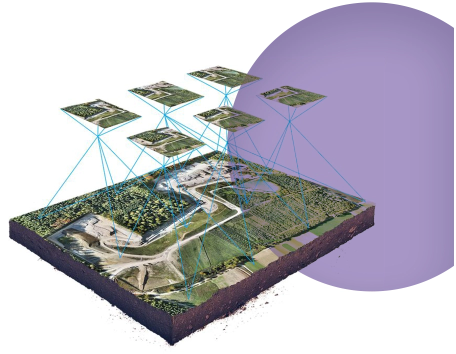
These industrial courses provide land surveyors, engineers, students, construction contractors, mine managers and interested parties with Graphics Information Systems knowledge related to industrial UAV mapping. *It is important to note that these courses do not use precision Real Time Kinetic (RTK) or similar geo-referencing hardware or software! All measurements are accurate to the Ground Sampling Distance (GSD). This means that all measurements including volume, area and straight line will be accurate to the GSD (which will be accurate to your real world measurements).
However, the geospatial reference will as accurate as the drones conventional GPS which will be accurate between 30cm and 1.5 m or more depending on the day. If geospatial accuracy is (ie, the drone map must line up precisely within the centimetre with Google maps for example) required, RTK or other precision geo-referencing equipment must be used. These courses are designed to give insight into the workings of drone based GIS and how it can be applied to industrial applications.

This course will teach you how to quantify cut and fill information on a mine site using drone data, photogrammetry outputs and open source GIS. Geowing Academy has left in some of the glitches so that you can see how open source is not always optimised when it is updated or alternative versions of the software are used, this will ensure that it does not come as a surprise when using updated or older/newer versions of the software.
You will need to download and install QGIS and Cloud Compare from the Software/ Hardware Requirements page for this course.
In this course you will learn

PART
ONE
- What photogrammetry outputs will be used in mine surveying
- How to correctly prepare your data for analysis
- Digitising the site correctly and what to look for
- Numbering stockpiles correctly
- Saving out the correct file formats for inter software use (Part 2)
- The Plugins Manager
- Quantifying stockpile: volumes, area, perimeter lengths
- Saving data tables
PART
TWO
- Stockpile analysis in complex environments
- Inter software file use
- How to correctly isolate stockpiles underneath complex machinery
- How to create a stockpile base correctly
- Quantify complex stockpile information
- Add data to existing stockpile data from Part 2 to Part 1 tables
- Ready data for reporting.
Free data is provided for this course
(check Course System Requirements page to make sure your computer can run the programs and therefore the data set)
Original price was: USD$250.00.USD$100.00Current price is: USD$100.00.

It is recommended that you complete the Keystone Courses first before doing the industrial Course
Take the FREE GeoWing Academy Mini Course here
These industrial courses provide land surveyors, engineers, students, construction contractors, mine managers and interested parties with Graphics Information Systems knowledge related to industrial UAV mapping. *It is important to note that these courses do not use precision Real Time Kinetic (RTK) or similar geo-referencing hardware or software! All measurements are accurate to the Ground Sampling Distance (GSD). This means that all measurements including volume, area and straight line will be accurate to the GSD (which will be accurate to your real world measurements).
However, the geospatial reference will as accurate as the drones conventional GPS which will be accurate between 30cm and 1.5 m or more depending on the day. If geospatial accuracy is (ie, the drone map must line up precisely within the centimetre with Google maps for example) required, RTK or other precision geo-referencing equipment must be used. These courses are designed to give insight into the workings of drone based GIS and how it can be applied to industrial applications.
This course will teach you how to quantify cut and fill information on a mine site using drone data, photogrammetry outputs and open source GIS. Geowing Academy has left in some of the glitches so that you can see how open source is not always optimised when it is updated or alternative versions of the software are used, this will ensure that it does not come as a surprise when using updated or older/newer versions of the software.
You will need to download and install QGIS and Cloud Compare from the Software/ Hardware Requirements page for this course.
In this course you will learn
PART
ONE
1. What photogrammetry outputs will be used in mine surveying
2. How to correctly prepare your data for analysis
3. Digitising the site correctly and what to look for
4. Numbering stockpiles correctly
5. Saving out the correct file formats for inter software use (Part 2)
6. The Plugins Manager
7. Quantifying stockpile: volumes, area, perimeter lengths
8. Saving data tables
PART
TWO
1. Stockpile analysis in complex environments
2. Inter software file use
3. How to correctly isolate stockpiles underneath complex machinery
4. How to create a stockpile base correctly
5. Quantify complex stockpile information
6. Add data to existing stockpile data from Part 2 to Part 1 tables
7. Ready data for reporting.
Free data is provided for this course
(check Course System Requirements page to make sure your computer can run the programs and therefore the data set)
Original price was: USD$250.00.USD$100.00Current price is: USD$100.00.
