Dam It! How drones can be used to survey potential dam and reservoir sites
15 years ago I was managing a game reserve in the Mapungubwe area in North Limpopo South Africa. The reserve had not had a permanent manager and there was some serious need for maintenance on fences, roads and dams. In fact there was only one of the four dams on the entire 3500ha reserve that had water in it. The rest had been damaged but flooding and neglect. One of my first tasks was to re-establish these vital water points. In order to do this, I had to use what’s known as a “Dumpy” level, a piece of equipment that allows you to read terrain levels in order to make sure that whatever you are building comes out level and straight, in this case it would have been the dam walls. Now you must understand that I had never used this sort of fancy pants equipment, so the learning curve was steep and fast. I was used to using a piece of string and a spirit level, so this new tech was a bit challenging to get right initially and walking back and forth across broken earth dam debris in 35 degree C heat to take measurements was time consuming. Needless to say, more colourful phrases other than “dam it” were thrown around as I fell over a number of times traversing the treacherous terrain with the cumbersome equipment. I remember thinking back then that I hoped the future would have easier ways of doing this sort of work.

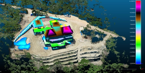
Image 1: One of the many broken dam walls on the property. This particular one, although not a true “earth” dam was destroyed during a flood. The erosion damage caused by the breach also had to be filled in and brush packing used to prevent any further erosion should it have rained again.
It would have been nice to be able to calculate the amount of material needed for the construction of the new dam wall for budgeting purposes but at the time I had no real survey knowledge to be able to work this out properly, so I gave a rough estimate and got on with it. I don’t like doing this because budgets are usually very tight when running game reserves. Over spend here, loose out there and with so much that needed to be done, there wasn’t much wriggle room at all.
Fast-forward to 2023 in another part of the country. I was asked by a member of the local farming community whether or not drones can be used for surveying potential dam sites that would be used to irrigate lucerne fields and orchards. The intended areas were shallow valleys that, should the earth dam walls be built, would flood providing hundreds of thousands of cubic metres of precious water to the surrounding farms. Well, that was the thinking anyway but the farmers could not be sure if these figures were true just by eyeballing it and wanted surveys done of each site to see which would yield the correct amount but they had a very limited time frame in which to do it. Having done dumpy level surveys on dams much smaller than the intended dams of this project, I knew that traditional survey methods would not work within their limited timeframe at all as they would take many days for each site. The terrain was rough and at least two trained surveyors would be needed to survey each site (surveyors for these sorts of projects come with a very high price tag as well).

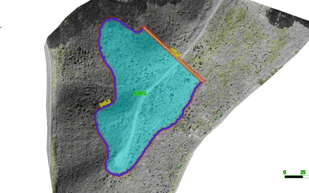
Image 2: This drone image is from another site but shows what a dam would look like once completed and shows the dam wall length, (108.5m) the flood plain perimetre length (excluding dam wall, 547m) and the volume of the dam (92 972 cubic metres).
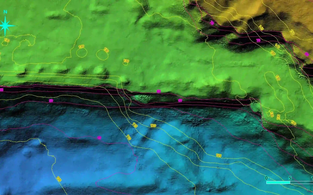
Challenge accepted! Admittedly, at this point I had not done a potential dam site survey with photogrammetry outputs but, as we know, when you are working with powerful GIS software and centimetre GSD (ground sampling distance) 3D data, you can do almost anything with regards to geospatial information acquisition. It took nearly five batteries for the DJI Phantom 4 Pro V2 (roughly 80 minutes of flying time) to collect the required data per site, averaging 1000 images per site, covering 59ha and 70 ha respectively. This turned out to be overkill but it is always better to collect more data than to find out you are short and have to redo the flights. It took about 3 hours of processing time per site to render the Digital Terrain Models (DTM) and high resolution orthomaps needed for the GIS site analysis. High precision georeferenced accuracy was not required for this project as the only numbers that were required where the flood plain areas, potential dam volume and potential dam wall length. (See https://geowingacademy.com/did-you-know-about-elevation-and-gps-offsets-between-drone-data-collected-on-different-dates-and-how-it-effects-photogrammetry-processing/ for more information on Relative vs Absolute drone map accuracy). Essentially, building a digital “virtual” dam was the name of the game for this project.

Image 3: Full scan area (70 ha) with p roposed dam outlined in yellow (926 064 cubic metres)
The GIS analysis part was a fairly straight forward process (well at this point, I had done cut/fill surveys for mines prior to this project so some of the GIS skills needed had already been learned prior to this project). The farmers had stipulated that they wanted a 50cm contour map as well as the volume, area and perimeter information. So 50 cm contours were computed using the DTM. Two orange road cones were placed where placed on the ground on either side of the valley on each site to show where the wall would be built between before the drone flight. These were then used to draw a digital “wall” and the contour line that intersected the potential dam wall was used to calculate the floodplain area and dam perimeter length. The potential dam volume was then calculated.

Table 1: The dam parameters calculated in GIS.
So everyone was happy and after 2 days the reports were sent off and the job was done. But I wasn’t satisfied. There must be a way to calculate the façade area of a potential earth dam wall as well which would allow for the calculation of materials needed for which can be factored into the budgeting process. So, with some assistance from an engineer, who asked me if it was possible to work out a number of different things in GIS in terms of horizontal and vertical measurements. I had not done this before but I knew it was possible (anything is possible with this amazing technology) so it was back to the drawing board and I set about how to work out a method for acquiring the various measurements that were needed. He then took these measurements and showed me how these can be used to calculate the façade area of the dam wall. This was brilliant! When you combine this information with the known measurement requirements for stable earth dam wall construction, you can calculate the estimated amount of material needed to complete the job quite accurately, so when it comes to compiling the budget report for the dam projects, Bobs your Auntie! You can learn how to quantify dam measurements with GeoWing Academy’s DAM IT! Course, a two part deep dive into all things dams!